Featured Post

Show HN: LegendAI-Amazon Sales Tracker https://ift.tt/Qmk4XB9

Show HN: LegendAI-Amazon Sales Tracker Get Actual Not Estimate Amazon Product Data! Real-Time Amazon Sales and Data Insights. Get accurate s...

Showing posts with label SFMTA. Show all posts

Wednesday, May 3, 2023

Just in Time for Bike Month: The Active Communities Plan Interactive Map!

Just in Time for Bike Month: The Active Communities Plan Interactive Map!
By Christopher Kidd

Image of a map with multiple lines seen. The legend on the bottom right includes about a half a dozen circles.

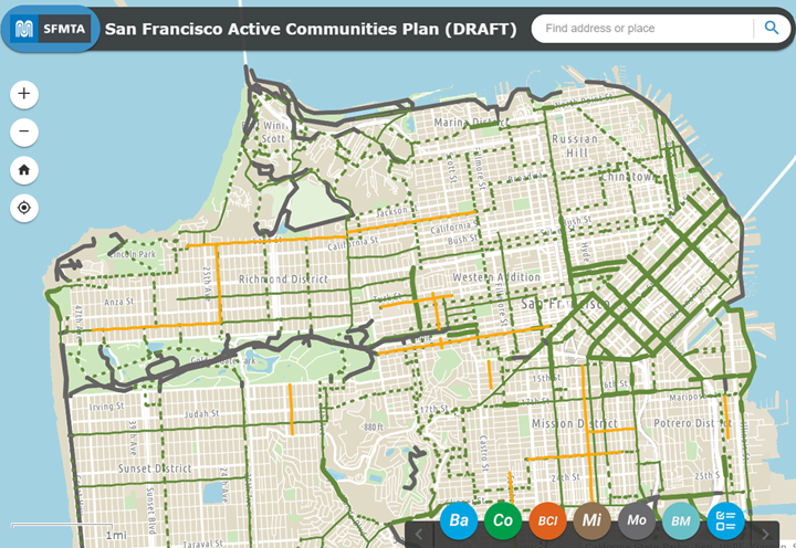
Image of the new Active Communities Plan (ACP ) interactive map 

As part of our ongoing public outreach about the Active Communities Plan, the SFMTA has created a new ACP interactive map.  The release of the map comes just a couple of weeks after we began collecting feedback through our new survey.  

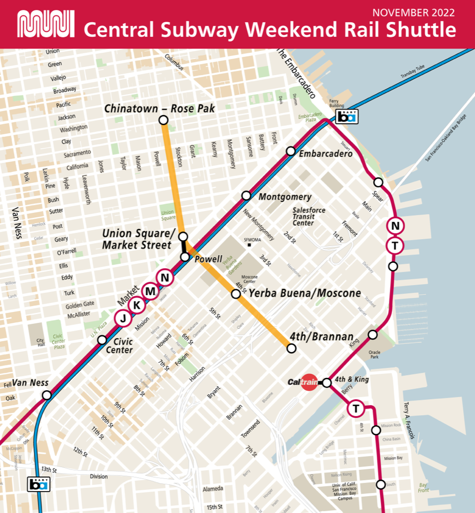
The map shows conditions for biking, scooting and rolling across San Francisco, as well as multiple layers of analysis conducted by the Active Communities Plan team. It is meant to help users understand how different factors like comfort, safety and network quality influence whether people decide to use active transportation or not.  

We want users to have the opportunity to explore and compare data, reflect on how it compares to their experiences with active transportation and provide input about what kinds of solutions work best. 

The interactive map has six main layers to explore: 

  • Baseline Data – shows today’s active transportation network, our pipeline of approved projects and the location of every public bike rack in the city. 
  • Collision Analysis – shows the locations of bike and scooter collisions on the High Injury Network before the pandemic (2017-2019) and since the start of the pandemic (2020-2021), as well as the neighborhoods with the most unreported (unlinked) bike & scooter collisions. 
  • Comfort Analysis – shows the Bike Network Comfort Index (BCI), which categorizes perceived comfort or risk by people biking, scooting or rolling. This is only our first draft of the BCI – by taking our survey, you can help shape how the BCI is scored! 
  • Micromobility Analysis – shows what streets people ride most when using BayWheels e-bikes or scooters, which BayWheels stations get the most ridership and the service areas for our micromobility providers. 
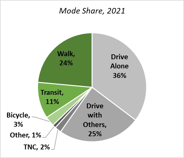
  • Modeshare Analysis – shows data from the American Communities Survey: commute mode share by bicycle and the distribution of zero-car households. 
  • Bike and Micromobility Activity Analysis – combines our BayWheels e-bike trip data, scooter trip data and modeled bike and scooter trip data from Replica to estimate the volume of trip activity. You can view activity across the city, on the active transportation network or by network facility type. 

Once you’ve had a chance to explore our interactive maps, take our survey. The results will help us understand your needs and barriers to active transportation, as well as how safe or comfortable people feel using different types of streets. From there we can develop network, program and policy recommendations that directly reflect the needs and priorities of people across the city. Our survey runs through July 31st.  

The Active Communities Plan public engagement effort has reached more than 1,000 residents since January, and we have events scheduled through mid-June with more to come throughout the summer. Visit Active Communities Plan (SFMTA.com/ActiveCommunities) for our schedule, which is updated regularly. If you want us to attend your community meeting or event, contact ActiveCommunities@sfmta.com and let us know! 


Published May 03, 2023 at 10:19AM
https://ift.tt/oXDzt0M

Monday, May 1, 2023

Three Golden Rules to Improve Scooter Safety

Three Golden Rules to Improve Scooter Safety
By Mona Chiu

The SFMTA has some exciting news for all who use the sidewalk in the city! Starting May 1, 2023, we'll be launching a new safety campaign to promote safe and responsible electric scooter use for both permitted scooter share devices and privately operated scooters. The campaign will focus on three key safety rules that every rider should keep in mind while riding: no sidewalk riding, no speeding and no double riding (two people riding one device). By educating riders about the dangers of sidewalk riding, unsafe speeding and riding, and improper parking, we hope to make the city safer for everyone.    

Animation images of cartoon animals riding a scooter. There are two images side by side. The left image shows a rabbit riding a scooter on the sidewalk with a turtle falling and a rhinoceros standing. The right image shows the same rabbit on a stationery scooter with the turtle and rhinoceros standing and smiling.

Sidewalk riding has been a major concern for pedestrians in San Francisco, and it's illegal to ride an electric scooter on the sidewalk.   

Animated image of a cat, turtle and rabbit on a scooter with a bear holding up their hand attempting to the stop the riders.

 Electric scooters can travel at speeds of up to 15 miles per hour, which can be dangerous if riders aren't paying attention to their surroundings. The SFMTA's safety campaign will encourage riders to be mindful of their speed (riding over 15 miles per hour is illegal) and to obey traffic laws

The campaign will also focus on emphasizing double riding is illegal. By law, only one rider should ride a scooter at a time.  

Animated image of a rabbit on the scooter with a bottle. They are confused and distraught.

To spread the word about this safety campaign, we will be placing posters on Muni buses, displaying ads in Muni bus stops and running ads on social media. This should help us reach as many scooter riders as possible and encourage them to prioritize safety while riding. 

Three images showing the side of a bus, a station platform sign and a close up of a car car inside a bus.

The SFMTA already has been actively working to improve scooter safety in San Francisco. We have implemented several policies and regulations, including: 

  • Requiring permitted scooter companies to provide a lock-to system to keep parked scooters out of the accessible path of travel  
  • Requiring permitted scooter companies to develop and implement a plan for safe riding. These plans include rider training, in-app messages with safety messages and sidewalk detection technology on their devices.  
  • Encouraging scooter permittees to adopt an escalating penalty structure for improper riding and parking 
  • Working with the Port of San Francisco to reduce sidewalk riding on the Embarcadero.  

The agency has also worked to improve infrastructure for scooter riders. We have installed: 

  • 3,000+ racks installed since the beginning of scooter permit program in 2018 
  • 11,000+ bike racks available citywide for scooter parking  
  • 465 miles of bikeways in San Francisco 
  • 78 miles off-street paths 
  • 139 miles of bike lanes (Class II) 
  • 43 miles of separated bikeways (Class IV)  
  • 45 miles of bike lanes and separated bikeways added since 2018 
  • 33 miles of Slow Streets 

The agency is also working to expand the active transportation network in the city through our new Active Communities Plan

If you want to report any complaints related to scooter riding, you can call 311 or visit the 311 website.  

To learn more about what the SFMTA is doing to promote a safe and useful scooter share system, visit our scooter share permit project page and view our data dashboards


Published May 01, 2023 at 12:32PM
https://ift.tt/YunLMZ0

Friday, April 28, 2023

Muni Metro Fix-It Week Maintains the Subway Infrastructure

Muni Metro Fix-It Week Maintains the Subway Infrastructure
By Jessie Liang

Several crew in safety gear standing over a rail track with tools angled in hand.

Track crew removing old rail at the Van Ness crossover 

The first Muni Metro Fix-It Week of 2023 was a resounding success in March, and it’s also the first Fix-It Week since the SFMTA launched the Central Subway in early January of this year. Here is a behind-the-scenes video recap. Fix-It Week is the SFMTA’s quarterly effort to optimize work time by closing Muni Metro early for critical maintenance. The SFMTA’s Maintenance of Way (MOW) teams did an excellent job maintaining the subway and preventing future breakdowns. 

Fix-It Week helps the Muni Metro get a 20% improvement in speed and about a 20% improvement in reliability in the subway. It takes fewer minutes to take the N Judah from the Outer Sunset to Embarcadero now than it did in 2019. 

 From March 16 to March 22, 2023, the Muni Metro Subway between Embarcadero and West Portal closed at 9:30 p.m. to provide SFMTA maintenance crews an extended window to perform underground infrastructure improvement work that cannot be completed during the usual overnight windows. During the subway closure, buses provided substitute service for Muni Metro lines on the surface and connected all stops on Market Street.   

Crew member on the back of a truck spraying water along the side of the tunnel wall. There is a map on the right side and a advertisement board on the left of a woman with sunglasses smiling.

Track crew powerwashing station walls

The goal of Fix-It Week is to make Muni metro subway operations more reliable, ensure safety, and improve the customer experience. Nine MOW teams, Track, Cable Car, Motive Power, Maintenance Engineering, Mechanical Systems, Overhead Lines, Underground, Paint Shop and Signal, were involved in the maintenance work. 

Major maintenance work includes: 

  • Track replacement and reinstallation from the Ferry Portal to the Van Ness Crossover 
  • Mechanical systems cleaning, maintenance and installation  
  • Signal repairs and upgrades, including the demolition of old train control system racks, equipment and wiring 
  •  Track fastener and subway lighting surveys, and drain cleaning around switches  
  • Overhead Line inspections and Overhead Section Break hardware adjustments 
  • Debris removal and traction power substation inspections 
  • Cable Car maintenance and repairs 

Several crew seen cleaning the ground in a station with a variety of posters and lights on the wall.

Custodial staff cleaning Church Station

The SFMTA teams completed over 2,000 hours of maintenance and inspections over the seven night shutdown. They were able to perform 161 feeder operations, replace more than 125 bulbs for trackway lighting in multiple locations, renew 750 feet of Overhead Contact System contact wire, replace eight blue light phones and inspect approximately 8,000 track fastener plates from the Ferry Portal to Powell Station. 

Several crew on spraying water on the tracks alongside a truck.

Track crew powerwashing and removing trash from trackway 

A support team was also contributed to the success of Fix-It Week. These staffers helped coordinate maintenance work, upheld all safety standards and ensured that subway service resumed on time every day. 

The SFMTA will continue to keep the Muni Metro system in a state of good repair. The next Fix-It Week is scheduled for July 2023, and we thank you for your patience and understanding while we do this vital work.  

For more information, visit Muni Metro Maintenance Project (SFMTA.com/SubwayMaintenance).  

Nearly a dozen crew in safety gear all standing on each side of rail track. They are holding the track.

Track crew moving new rail into position by hand at the Van Ness Crossover 


Published April 28, 2023 at 02:17PM
https://ift.tt/sA06cfB

Friday, March 17, 2023

San Francisco’s Transit-First Policy Turns 50

San Francisco’s Transit-First Policy Turns 50
By Michael Delia

Two buses, a bicyclist, a pedestrian and person riding a scooter all on Market Street.

Transit on Market Street in downtown San Francisco, 2018

It’s been a half-century since the San Francisco Board of Supervisors put transit needs above all other traffic initiatives, and now, the city’s Transit-First policy is celebrating its golden anniversary. The policy guides the city’s work on major infrastructure projects and planning efforts. Its principles drive San Francisco officials to promote incentives that reduce traffic congestion and solo vehicle trips, support transit investments including the purchase of Muni buses and light rail vehicles, and regularly evaluate how well our transportation network functions. 

Adopted on March 19, 1973, the original Transit-First policy was born out of an effort to reshape the Municipal Railway so it could serve San Franciscans' needs more effectively. The goals were very specific: 

  • Create exclusive bus lanes and prohibit automobiles from streetcar and cable car tracks. 
  • Restrict turning movements of automobiles that conflicted with transit vehicles. 
  • Extend sidewalks at transit stops to allow boarding from the travel lane.  
  • Strictly enforce parking codes and tow-away regulations along major transit corridors. 
  • Consider the use of preemptive traffic signals for transit vehicles. 

By the early 70s, San Francisco streets had become increasingly crowded. The Freeway Revolt just over a decade earlier led to the cancellation of planned highway construction in the city, and an office boom downtown was bringing in thousands of commuters. Meanwhile, the San Francisco Bay Area Urban Renewal Association (SPUR) began a comprehensive review of Muni’s operations in 1972. The organization interviewed operators and management, conducted line checks and reviewed company properties and processes to identify areas for improvement. 

“The recurring theme was most Muni vehicles were operating in traffic. This was the source of many problems — schedule bunching, accidents, unhappy operators and riders,” said Jim Chappell, executive director of SPUR from 1994-2009. 

The recommendations in SPUR’s report, “Building a New Muni,” were well-received by the mayor and city supervisors, and the Transit-First policy was passed not long after its release. Transit-First also addressed concerns about increased air pollution and environmental damage by effectively putting the personal automobile on notice. 

Cable car tracks with the words “keep out” painted over the street.

Transit-only lane along the Powell Street cable car tracks from California to Pine Street | November 27, 1973 

New equipment, transit priority and a focus on complete funding for Muni were initial hallmarks of the policy. The passage of Proposition E, a city charter amendment, in 1999 further enhanced Transit-First by including protections in the landmark legislation for people walking and bicycling. 

“San Francisco’s Board of Supervisors showed remarkable foresight in adopting the Transit-First resolution, and it no doubt helped San Francisco remain one of the strongest public transit cities in the nation,” said Jason Henderson, San Francisco State University Geography and Environment professor and author of Street Fight: The Politics of Mobility in San Francisco.  

In addition to making transit, walking and biking more attractive, Transit-First also promotes equity. When residents have options beyond cars, employment and economic opportunity can grow, as does the opportunity to reduce greenhouse gases. 

Professor Henderson believes San Francisco was the first city in the country to adopt a policy to prioritize public transit, but that doesn’t mean the work is done. “Transit-First must no longer be advisory,” he said. “[New policies are] needed so that public transit, cycling and walking are more than aspirational.”   

In recent years, the “Muni Forward” program has reflected the Transit-First policy with 80 miles of transit priority street improvements. Among those improvements, diamond-marked transit lanes have evolved to become the present-day “Red Carpet” lanes reserved exclusively for buses and taxis to reduce travel times and the impact of traffic congestion on Muni schedules. Meanwhile, Market Street has gone through various redesigns in the downtown area over the years. Following boarding island and lane improvements, San Francisco’s busiest thoroughfare received its first red transit lanes in 2014 and was declared “Car Free” in a monumental celebration on January 29, 2020. 

Three people board a Muni bus on Van Ness Avenue in front of City Hall.

Riders board a 49 Van Ness/Mission bus near City Hall 

Today we can see the Transit-First policy in action in the now open Central Subway and projects such as the Van Ness Bus Rapid Transit (BRT) corridor and the Muni Forward L Taraval Improvement Project that is now under construction to add transit lanes, make the route more accessible and improve pedestrian safety and visibility. With Transit-First entering its 51st year, there are new challenges as the COVID-19 pandemic has driven many people back into private cars. However, the SFMTA’s improvement projects continue with a focus on proven strategies that make transit, walking and bicycling the city’s preferred modes of travel. 


Published March 17, 2023 at 02:12PM
https://ift.tt/hdRrCVW

Tuesday, February 28, 2023

Black History Lost and Found: Dorothy Jaymes and Accessible Transit

Black History Lost and Found: Dorothy Jaymes and Accessible Transit
By Jeremy Menzies

We continue to celebrate Black History Month by sharing the stories of SFMTA staff whose revolutionary work helped pave the way for future generations of Muni riders. Today, we look at the incredible contributions of Dorothy Jaymes, who played a critical role in helping advance accessibility on transit in San Francisco at a time when little was being done.  

Employees standing in between shelving holding various items such as a umbrella, tennis racket and bicycles. The shelving is filled with additional various items.

Jaymes (left, holding tennis racket) with her assistant, Linda Westry in the Muni Lost & Found Department in 1977. 

Born in Lake Charles, Louisiana, Jaymes started her career in Muni’s Lost & Found Department in the 1970s. According to a 1977  article in the department newsletter, Trolley Topics, she took her job seriously, accounting for every lost item no matter how small or large. 

Around the same time, protests by local disability rights advocates exposed the issues of poor access to public transit to local officials. The city responded in part by seeking contracts for new buses with passenger lifts in 1978 and by establishing the Elderly & Handicapped Program, to which Jaymes was a foundational contributor. 

Group photo of employees. The back row of three staff is standing. The front row of three staff is seated. One emplyee is wearing a Muni work vest.

Members of Muni Elderly & Handicapped Office staff in 1985, with Jaymes at center. 

By October 1979, Jaymes headed up the E&H Office and was responsible for processing applications for discounted transit fare cards. An early version of the Free Muni for People with Disabilities Program, this program lowered the cost of transit for people who needed it most. 

Jaymes’ role in the office played a critical part in improving access to transit for all San Franciscans. 

Employee smiling and holding a vintage card camera

Working out of a room in the Muni Photo Department, Jaymes wields an ID card camera in this 1979 photo. 

She left Muni in 1990 and finished out her career with the City of San Francisco at the Planning Department, before retiring in the early 2000s. Jaymes returned to Louisiana in retirement and passed away in 2015 at age 89. One of her former San Francisco co-workers remembered her as “a wonderful woman who was strong and always stood up for the workers.” 

So often, we only hear the stories of major figures and their brave breakthroughs in history. Capturing the full story begins with also celebrating and recognizing the contributions of our “unsung heroes,” whose daily work is still helping Muni riders today.  


Published February 28, 2023 at 12:31PM
https://ift.tt/W83hx9X

Tuesday, February 14, 2023

New Express Service Comes to the 1 California

New Express Service Comes to the 1 California
By Melissa Culross

Photo showing a pole on the street painted yellow that says bus stop, 1, 1X

Newly painted Muni flag stop indicating the pilot 1X California Express

Beginning February 21, 2023, a pilot program will offer express bus service on the new 1X California Express between the Richmond neighborhood and the Financial District. The SFMTA plays a significant role in San Francisco’s economic recovery, and this pilot that serves downtown is part of that. 

We have been working on improving travel time and reliability over the last several years. Travel times are now 11% quicker on the 1 California thanks to new transit lanes on California, Clay and Sacramento streets. But our work is not done on the corridor! The new 1X California express will provide another option for riders to zoom from the inner Richmond into and out of downtown even faster. We also expect this service to ease crowding on the 1 California as more people head back to the office. 

Three morning 1X California Express buses will depart from 33rd Avenue and Geary Boulevard at 8:00 a.m., 8:30 a.m. and 9:00 a.m. They will make stops along 33rd Avenue, 32nd Avenue and California Street until Arguello Street, then express straight to Downtown.  

Three afternoon 1X California Express buses back to the Richmond will depart from Sacramento and Davis streets at 4:30 p.m., 5:00 p.m. and 5:30 p.m. They will make three downtown stops and then express straight to Arguello and California. The first two outbound stops of the 1X California Express have been aligned with 1 California local stops to improve convenience for Muni customers. The last downtown stop is at David and Pine streets.  

You can find more detailed service information on the 1X route page (SFMTA.com/1X). 

The SFMTA is monitoring this pilot and will evaluate whether to make it permanent based on the needs of our riders. Let us know what you think at the Muni Feedback page. 

We are excited about this opportunity to support the recovery of downtown San Francisco by offering people this swift way to get there. 


Published February 14, 2023 at 01:01PM
https://ift.tt/REmjvB0

Wednesday, December 28, 2022

Free Muni for New Year’s Eve

Free Muni for New Year’s Eve
By Stephen Chun

White text "Leave the driving to us with additional advisory subtitles" on a red canvas background with city skyline silhouette.

For the 23rd consecutive year, the San Francisco Municipal Transportation Agency (SFMTA) will offer free rides on New Year’s Eve from 8 p.m. on Saturday, December 31 through 5 a.m. on Sunday, January 1. Extra Muni Metro Subway Service will be provided from 8 p.m. Saturday to 2:15 a.m. Sunday. Extra Owl Service will be provided from 10 p.m. Saturday to 5 a.m. Sunday

This program supports San Francisco’s Vision Zero goal to eliminate traffic fatalities.

Ride Muni Free New Year’s Eve includes all Muni lines and routes. Clipper Card customers should NOT tap their cards to make sure they don’t get charged a fare. Muni Mobile passes will not be necessary. Metro fare gates will be open that night. All information, including schedules and stops, will be posted on New Year's Eve Free Muni and Extra Service or SFMTA.com/NYE. Clipper Card customers should NOT tap their cards to make sure they don’t get charged a fare.

Don’t drink and drive, let Muni do the driving.

New Year's Eve Muni Service

  • Complimentary Muni service from 8 p.m. Saturday, December 31 to 5 a.m. Sunday, January 1.
  • Please do not tag your Clipper® card. If you tag it, you will be charged.
  • Please do not activate a MuniMobile ticket. Metro fare gates will be open.
  • Extra Muni Metro service:
    • Trains between West Portal Station and 4th & King from 8 p.m. to 2:15 a.m.
    • Additional trains between West Portal and Embarcadero Station from 8 p.m. to 2:15 a.m.
    • Transfer at West Portal Station to OWL bus lines.
  • Extra service on the OWL Network, from 10 p.m. to 5 a.m.:

At midnight on New Year’s Eve, a city-sponsored fireworks show from a barge off The Embarcadero, south of the Ferry Building, will take place. Motorists should anticipate delays in the area from approximately 11 p.m. to 1 a.m. and pedestrians are advised to use caution when traveling.

Note: Central Subway will provide free rail shuttle service from Chinatown Rose-Pak to 4th / Brannan St on Saturday, December 31st and Sunday, January 1st from 8 am to 5 pm, instead of midnight. We encourage those planning to use the Central Subway after 5 p.m. this weekend to use the 30 Stockton and 45 Union/Stockton which are scheduled to come every 15-20 minutes. For further information on our staffing & service plans, please visit Central Subway Will Close Early On The Holiday Weekends.

Regional Transit Connections for New Year's Eve

  • BART will provide additional service on January 1.
    • Full fare pricing will be in effect.
    • The last East Bay bound train running through Downtown San Francisco will be at around 1:30am and the last Southbound train heading toward Millbrae will run through Downtown San Francisco at 2:10am.
    • For more details & trip times, please visit BART’s New Year’s Eve service article.
  • Caltrain service will be running on a Weekend Schedule. For more details, please visit https://www.caltrain.com
  • SamTrans service will be from 8 p.m. on December 31 until 3:30 am on January 1. For more details, please visit http://www.samtrans.com 


Published December 28, 2022 at 03:33PM
https://ift.tt/60SU7wD

Thursday, December 15, 2022

A Brief History of the T Third Part 2: 1980s-2023

A Brief History of the T Third Part 2: 1980s-2023
By Jeremy Menzies

Beginning in January 2023 full service on the new T Third extension 2023 will run from Sunnydale to Chinatown every day. In this two-part blog series, we will look back at some of the history of the T Third Street line. Part 1, published last month goes through the first 100+ years. In Part 2, we look at the recent history of the T Third and Central Subway projects from the 1980s to today. 

The Call for Better Transit: 1980s-90s 

In the decades following World War II, the neighborhoods along the southern end of 3rd Street became more economically depressed and transit service declined.  Residents felt cut off from the rest of the city as bus service did not meet their needs. 

Passengers lining up to board a bus on a busy city street with buildings in the background 
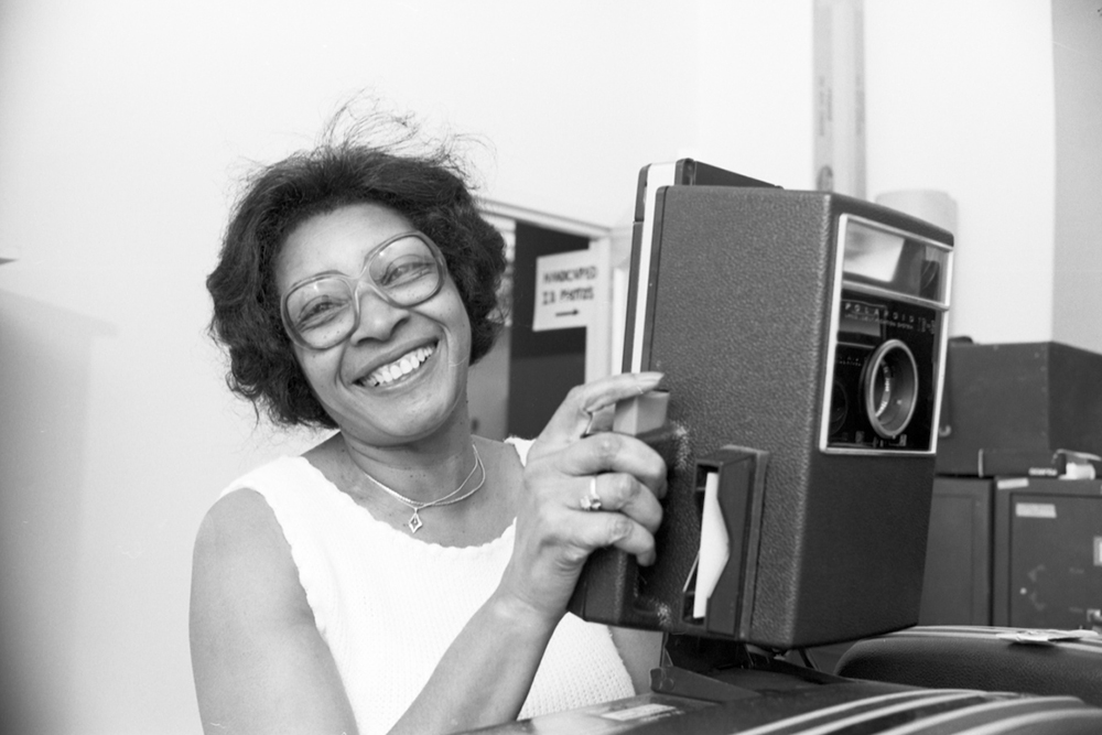
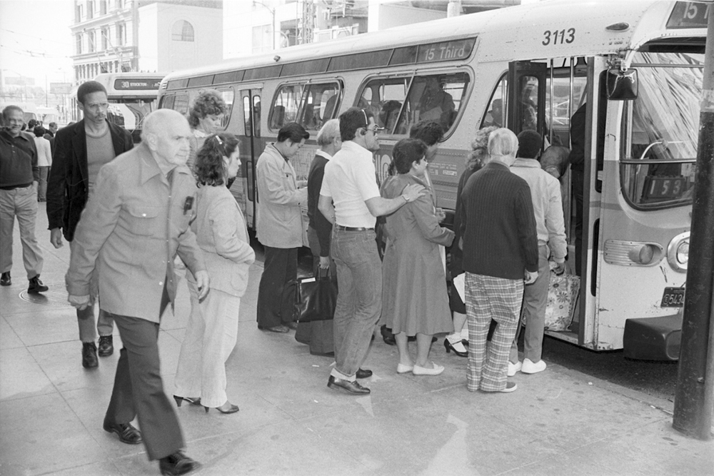
People boarding a 15 Route bus on 3rd Street near Market in 1983. Bus service on the 15 provided critical north-south service through the City’s busiest areas. 

In the late 1980s, the city was looking to revitalize the Mission Bay, Dogpatch, and Bayview and reliable transit was critical to this goal. Early outreach and research resulted in the 1993 Bayshore Transit Study. This initial plan solicited community input on several possible solutions on how to improve transit to these neighborhoods. Two years later in 1995, the Four Corridor Plan built upon the Bayshore Transit Study and elevated 3rd street as the top priority for San Francisco’s long-range transit plan. It was clear that residents, particularly in Bayview, wanted rail service to return to 3rd Street. 

T Third Phase 1: 1990s-2007 

These reports and outreach formed the backbone of the Third Street Light Rail Project, which would be built in two initial Phases. Phase 1 involved extending Muni Metro service from 4th and King to Bayshore Boulevard along 3rd Street. Phase 2 would focus on the 4th and Stockton corridors to extend the service into Chinatown and possibly North Beach. 

By the end of the ‘90s, funding was coming in to make Phase 1 a reality. Early plans for the T also included a new rail maintenance facility, Muni Metro East, as well as a turnback loop in Mission Bay and a direct connection to the Bayshore Caltrain Station. Due to various factors during preconstruction planning, the Mission Bay Loop and Bayshore Caltrain connection were dropped from the T Line plan. 

People in business attire and hard hats smiling with shovels in hand over a large pile of dirt under s station structure

A groundbreaking ceremony for T Third construction was held on May 28, 2002 at the 4th and King Caltrain Station.  

Construction of 5.1 miles of new tracks, overhead power lines, lighting, stations, and a variety of other improvements took five years to complete. On January 13, 2007, free weekend shuttle service commenced on the new line and full weekday service started on April 7. Just one year later in 2008, the Muni Metro East rail yard opened, boosting Muni’s ability to serve the new line. For the first time in 50 years, rail service returned to the eastern waterfront. 

A long perspective view of a corridor showing the city's neighborhood skyline 
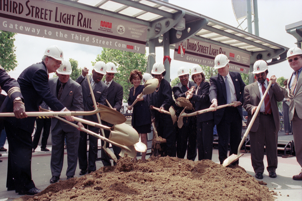
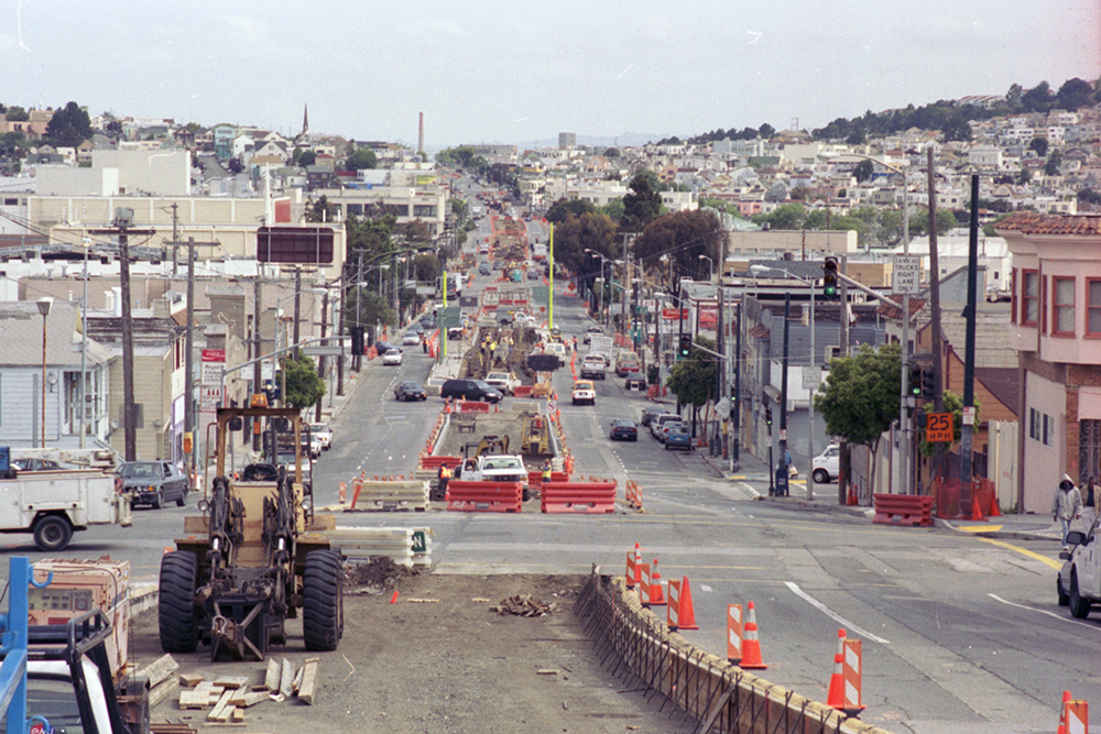
View north along 3rd Street at Jamestown Avenue during construction in 2004. 

T Third Phase 2: Central Subway 

Planning and outreach for Phase 2 of the T Line had already begun when the line opened in 2007. The Central Subway Project was created to address the transit needs of Chinatown, Union Square and South of Market. Construction would extend the T nearly two miles and build the first new subway in the city since the 1970s.

Construction and crew underground in a front of two boring entrances 
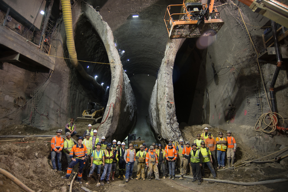
This 2016 photo, taken inside the excavation for Chinatown Station shows the massive scale of the Central Subway Project. 

Early proposals showed the Central Subway traveling north on 3rd Street and along Geary where it would turn up Stockton to end in Chinatown. Going south, the line would branch and exit the tunnel on 4th Street. The challenges of construction along 3rd and at Market Street resulted in a plan to run the line on 4th and Stockton streets. It was also decided to tunnel underneath the Market Street Subway/BART tunnels using special tunnel boring machines instead of more conventional construction methods. 

The official groundbreaking ceremony took place on February 9, 2010. The arduous process of building a subway with four stations through San Francisco’s densest neighborhoods began soon after. Despite an intensive construction period with project delays and cost increases, the Central Subway opened for service on November 19, 2022.  

Passengers boarding onto a train in a station on a busy platform
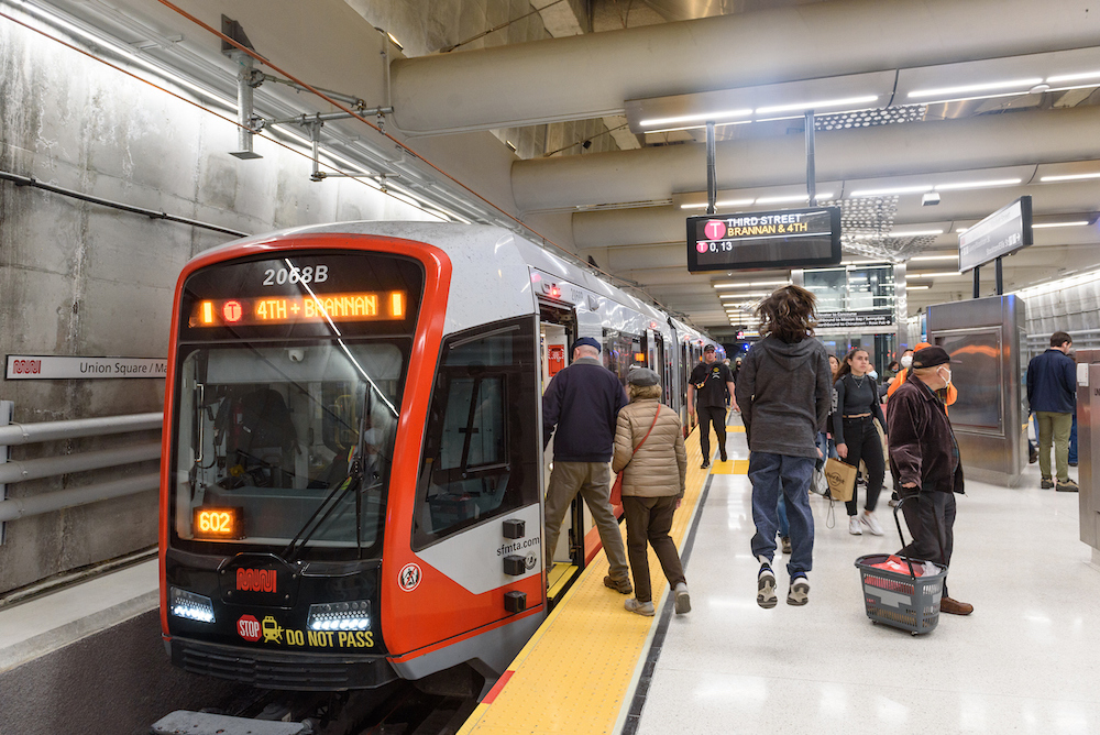
Opening day of the Central Subway on November 19, 2022. Thousands of people came out to see and ride in the long-awaited subway. 

Over 30 years in the making, the T Third line follows in the footsteps of the first horsecars that ran over 160 years ago. However, this is not the end of the line for the T. Planning is already underway on the T Third Phase 3 extension. Aimed at expanding service beyond 3rd Street, this extension will mark yet another chapter in San Francisco’s transportation history. 


Published December 15, 2022 at 02:22PM
https://ift.tt/nKZi6My

Tuesday, November 1, 2022

Central Subway Opens November 19 with Special Weekend Service

Central Subway Opens November 19 with Special Weekend Service
By Mariana Maguire

Map showing the existing Muni Metro system's J, K, L Bus, M, N and T lines with the new Central Subway connecting at Powell Station. The Central Subway goes to Chinatown-Rose Pak Station at Stockton and Clay, Union Square/Market Street Station at Geary and Stockton, Yerba Buena/Moscone Station at 4th and Folsom and 4th & Brannan Station at 4th and Brannan.

Central Subway special weekend service starts November 19 with service to Chinatown-Rose Pak Station, Union Square/Market Street Station, Yerba Buena/Moscone Station and 4th and Brannan.

On Saturday, November 19, the Central Subway makes its historic debut with special weekend service, Saturdays and Sundays, from 8 a.m. to 12 a.m. with trains every 12 minutes. During this special weekend service, customers will have a chance to ride through the new Central Subway for free and get to know the four new stations: Chinatown-Rose Pak at Stockton and Clay streets, Union Square/Market Street Station at Geary and Stockton streets, Yerba Buena/Moscone Station at 4th and Folsom and the new 4th & Brannan stop at 4th and Brannan streets.

During the special weekend service, customers can transfer to the new Central Subway service at Powell Station from Muni Metro and BART by walking underground to the new Union Square/Market Street Station.

The new Central Subway connects communities to destinations including Chinatown, Union Square, Yerba Buena Gardens, the Moscone Convention Centre, the Metreon and SFMOMA, just in time for the holidays.

Wayfinding Guidance

SFMTA ambassadors will provide wayfinding guidance online and in-person during special weekend service to help customers learn to navigate the new Central Subway stations and Muni Metro connections.

Online guidance will include a video that will be available on our website. Visit our Service Changes webpage (SFMTA.com/ServiceChanges) to learn more and sign up for a tour.

New T Third service in Central Subway is planned to start January 7

Beginning Saturday, January 7, SFMTA is planning to run the new T Third line service via Central Subway seven days a week, providing a direct connection from Chinatown-Rose Pak Station to Sunnydale. Weekday service will run from 6 a.m. to 12 a.m.. and weekend service will run from 8 a.m. to 12 a.m.. Stay tuned for more details!


Published November 01, 2022 at 02:38PM
https://ift.tt/qNvig7s

Friday, October 28, 2022

What’s new on the west side?

What’s new on the west side?
By Andrea Buffa

The west side of San Francisco is home to some of San Francisco’s most beloved recreational destinations — Golden Gate Park, the Presidio, Lake Merced, Fort Funston and Ocean Beach, among others. But many of these natural attractions — and others like Mt. Sutro and Twin Peaks — are also geographic barriers that can make travel to and from the west side of the city more difficult.

This may be one reason why three out of four people traveling within, to or from the west side do so by personal car. It’s also why we need to make sure there are more safe, reliable and affordable transportation options between west side neighborhoods and other citywide destinations.

This month we released an interactive website, San Francisco’s West Side on the Move, describing local experiences, transportation challenges and solutions in neighborhoods from the Richmond and the Sunset to Lake Merced, Parkside and West Portal. The website pulls together our latest efforts to make it safer and more convenient for people on the west side to get where they need to go. Our goal is for people who want to take Muni to have reliable and frequent service; for those who want to walk or bike to have safe streets; and for people who drive to face less congestion.

Beyond the geographic barriers that impede west side travel, other transportation challenges on the west side include street closures caused by construction projects and frequent closure of the Great Highway for sand removal. Street transformations that began during the pandemic, like Slow Streets and the closure of some roads in Golden Gate Park to cars, also altered some residents' trip patterns. We've been listening to and collaborating with community members on the west side about how to better address these challenges and meet their needs as well.

San Francisco’s West Side on the Move describes the solutions we’ve implemented or plan to implement soon on the west side. Our Transit team has already made major strides in improving west side Muni lines like the 38 Geary and 5R Fulton Rapid using tools like red transit lanes, bus bulbs and smart traffic signals. Travel times on the 38 Geary are up to 20% faster than they were previously, and travel times on the 5R Fulton Rapid are up to 12% faster. We’ve also improved travel times on the 1 California and the N Judah.

While the L Taraval Improvement Project is still in construction, it has already delivered important safety benefits. On the completed section of the L Taraval, which finished on time and on budget, pedestrian injuries decreased by 60%. Improvements like this are vitally important in all San Francisco communities, and especially so in this part of the city which is home to so many older adults and families with small children.

When it comes to reducing congestion, we are adjusting signal timing to keep up with changing traffic patterns, adding turn lanes and restrictions in key locations and providing more loading zones in commercial areas to reduce double-parking. We also monitor the network for opportunities to improve bottlenecks, such as the recently re-opened MLK Drive between Chain of Lakes Drive and Sunset Boulevard.

To slow down traffic on residential streets and make walking and bicycling safer and more enjoyable, we’re using traffic calming tools like speed bumps to slow vehicle speeds. In 2021, the SFTMTA invested in a comprehensive package of traffic calming measures in the Outer Sunset to address local concerns. Monitoring indicates that traffic speed and volume was reduced, which ideally creates safer conditions for all road users.

While the Slow Streets program has provided valuable, safe routes for people who walk, bike and roll, we've heard from residents that they're not working well for every community, particularly the Sunset. There, the Sunset Neighborways program is replacing Slow Streets to create a network of safe streets for active transportation. The emphasis of Sunset Neighborways will be on slowing down traffic to improve safety, rather than restricting it. In the Richmond, Anza Street is a key corridor for biking and active transportation, and in response to community requests for a better east-west bike route through the neighborhood, we added bike lanes and safety improvements like speed cushions to slow traffic and create a street that can be easily and safely shared by cyclists and drivers. 

By releasing San Francisco’s West Side on the Move, the SFMTA hopes to deepen its dialogue with west side community members about what’s working well and what can be improved when it comes to keeping the west side moving. Please share your ideas by emailing WestsideProjects@SFMTA.com

Should we say how important the decrease in pedestrian injuries is so significant given how many seniors and families with small kids live in the area?


Published October 28, 2022 at 05:19PM
https://ift.tt/8xZFG6X

Thursday, September 29, 2022

What a Year It Has Been! Let the Celebration of Transit Month Continue

What a Year It Has Been! Let the Celebration of Transit Month Continue
By Erin McMillan

Muni bus stopped at intersection and unloading passengers at bus stop.

49 Van Ness/Mission using the brand new bus rapid transit lanes on opening day in April.

During Transit Month this September, we’re continuing the celebration by looking back to more of the work we’ve done over the last year— some that has been less obvious to Muni customers, but critical to a well-functioning system and other work that is more front and center.

Fix It! Week and Continuing State of good Repair Work

Muni is an impressive transit system. Moving thousands of people on rail and buses every day takes a lot of coordination and a lot of work. Dealing with unique challenges like San Francisco’s geography and shifting travel patterns, we also have to deal with issues related to the Muni system’s age. Proper care and maintenance of a transit system many decades old takes strategic planning as regular maintenance needs to happen while continuing to provide service. Typically, regular Muni Metro maintenance work occurs each night after subway service hours, SFMTA maintenance crews work to maintain the tracks and equipment underground. On most nights, this gives crews only about two hours to get work done. This two-hour window sometimes isn’t enough to complete critical maintenance tasks, so beginning in April, we started Fix It! Week, a quarterly week of planned maintenance that occurs during extended, overnight shifts when trains aren’t in service.

This year Fix It! Week provided 63 total work hours during which several SFMTA teams completed over 2,000 hours of maintenance and inspections. On the busiest nights, the maintenance teams had up to 55 staff in the tunnel from West Portal to Embarcadero delivering safety improvements, station and tunnel enhancements, subway track and wayside equipment maintenance, and traction power upgrades.  

In addition to finding new and creative ways to maintain the system more efficiently, we also had to entirely reimagine the service network to accommodate changing travel patterns and in response to the pandemic. Over the past year alone we’ve increased Muni service multiple times as the impact of the pandemic has eased and we’ve slowly been able to hire new operators.

Trip patterns have changed over the last two years with a noticeable shift in San Francisco residents traveling neighborhood to neighborhood instead of the peak period downtown-centric travel pattern that was prevalent pre-pandemic. And we’ve adjusted. Service is slightly over-supplied so that there is capacity when it is needed. Anticipating how people will move in the future is difficult, but our service planning team is hard at work tracking ridership, customer feedback and operator availability to do our best to accommodate how folks want and need to move around the city. We are working to build back our ridership by providing high-quality, reliable service that people can count on.

Our response was the 2022 Muni Service Network which was developed through an extensive outreach process. Throughout the COVID-19 emergency and recovery, the SFMTA prioritized restoring service to these, and other neighborhoods identified in the Muni Service Equity Plan.

On the more visible side of our work, in April we started bus rapid transit (BRT) service on Van Ness Avenue as part of Muni’s Rapid Network, which prioritizes frequency and reliability for customers. Muni and Golden Gate Transit customers are already experiencing shorter travel times. With dedicated transit lanes in the middle of the street, enhanced traffic signals with Transit Signal Priority, the Van Ness BRT is the fastest way to travel north-south in this part of San Francisco, and riders are noticing. Since the BRT corridor opened on Van Ness Avenue in April, ridership on the 49 Van Ness/Mission has nearly doubled and is exceeding pre-pandemic ridership by 13%.

In other major capital and service news, last October service started on Geary in its new transit lanes after the completion of the Geary Rapid Project. Pre-pandemic, the combined Geary routes had one of the highest bus riderships in the country, with more than 56,000 daily customers relying on the 38 Geary and 38R Geary Rapid. As riders return, they are experiencing a faster, more reliable ride thanks to transit improvements like red colorization and dedicated transit lanes, bus stop optimization and signal retiming that were made along the three-mile stretch of Geary. These quick-build improvements alone resulted in 38R Geary Rapid travel time savings of up to 20%. 

And last but certainly not least, you may have heard we have officially announced the opening of Central Subway! Weekend service starts Saturday, November 19 and will give customers a chance to check out its four new stations, and also allow our operators and crews to work out any kinks while operating. We’re looking forward to welcoming you aboard!

Wishing you a Happy Transit Month! 


Published September 29, 2022 at 01:37PM
https://ift.tt/E1pc8Zk

Thursday, September 1, 2022

Let’s Celebrate During Transit Month this September

Let’s Celebrate During Transit Month this September
By Erin McMillan

Muni bus traveling in the transit lane on Geary Boulevard.

The 38R Geary Rapid reaping the benefits of the Temporary Emergency Transit Lane on Geary Boulevard.

Today marks the start of Transit Month! Every year we look forward to celebrating Transit Month by looking back at all the successes of the previous year—and also by thinking of our upcoming opportunities to continue to improve Muni.

Over the past year, we have made a series of improvements through our Muni Forward program that reduced travel times, wait times and crowding:  

  • Reduced travel time by up to 31% on key bus routes as part of  the Temporary Emergency Transit Lanes program, giving more riders the benefit of the transit lanes faster.  
    • 10 miles of transit lanes were made permanent benefitting the T Third, 1 California, 14 Mission, 19 Polk, 27 Bryant, 38 Geary, 43 Masonic and the 44 O’Shaughnessy. This cool animation shows how transit priority is improving Muni travel times citywide!
    • As part of the TETL program, last October, the San Francisco Transit Riders gave us an award to honor the “Fastest Expansion of Transit Lanes in San Francisco History.”
  • Started bus rapid transit service on Van Ness Avenue, with initial weekday travel time savings of up to 35% on northbound trips, equating to 9 minutes a trip. And southbound, up to 22% travel time savings, or 5 minutes on a trip.   
  • Completed the Geary Rapid Project, which improved one of the city’s busiest corridors with much-needed safety improvements and more reliable bus service for the 38 Geary and 38R Geary Rapid’s over 56,000 daily customers.
  • Installed the one of a kind urban high-occupancy vehicle (HOV) lanes along Park Presidio Boulevard and Lombard Street that expands the capacity of those streets to carry more people with the same number of lanes.  
  • Reduced collisions on California Street by 64% for all modes and 89% for transit as measured in the evaluation of the California Street Safety Project.
  • Began implementing spot improvements to the top ten corridors where Muni experiences delay as part of the Transit Delay Hot Spots Program. The improvements feel small but benefit the full route.
  • Continued construction of transit reliability improvements on 19th Avenue, Taraval Street, 16th Street, Mission Street in SoMa, and along the 27 Bryant in the Tenderloin.

To see locations where Muni Forward improvements have been made across the city, check out this interactive Photo Map. Whether targeted spot locations, or along major corridors, improvements to the Muni network benefits everyone.

And looking ahead, we have started planning for Muni Forward improvements to the J Church, K Ingleside, M Ocean View, N Judah, 29 Sunset and 38 Geary. For some Muni lines, we hope to implement quick-build improvements as soon as next year! To support this work, and other work across the SFMTA, we were recently awarded $116 million from the California State Transportation Agency of the Transit and Intercity Rail Capital Program (TIRCP). Be on the lookout for more improvements coming soon!

Of course, that’s not all we’re doing to improve transit: we’ve been restoring service across the system, rehabilitating our subway system, and we’re putting the final touches on the Central Subway. Read more about our progress on enhancing transit service and safety in San Francisco.

Happy Transit Month, Muni riders! And for more information on the San Francisco Transit Riders Ride Along & Rally Wednesday, September 7  from 8 am - 10 am, please visit San Francisco Ride Along & Rally.


Published September 01, 2022 at 02:19PM
https://ift.tt/rtgXny3

Tuesday, August 2, 2022

Muni is Ready to Take Kids Back to School

Muni is Ready to Take Kids Back to School
By Shalon Rogers

Students boarding the 30 Stockton bus, as well as crossing the street to catch the bus. 

Photo caption: Every SFUSD elementary, middle and high school is served by at least one Muni route and are within a five-minute walk of a Muni stop 

As the first day of school for San Francisco students approaches, the SFMTA wants to ensure that families have reliable, efficient transportation to get them to and from school.  

To help determine which bus your child can take to school, the SFMTA has put together a list of Muni routes that serve SFUSD schools. This resource shows the closest transit options for all San Francisco public elementary, middle and high schools. You can also plan your student’s door-to-door trip on Muni, biking or walking with the SFMTA’s trip planner

Service changes implemented in July, including the restoration of the 2 Sutter, 6 Parnassus and 21 Hayes, as well as the extension of the 23 Monterey down Sloat Boulevard and the 43 Masonic to the Marina, have ensured that at least one or more Muni routes provides transportation to all SFUSD schools.   

Additionally, Muni school trippers will provide service throughout the school year. School trippers are extra buses on existing routes that meet students after school at some of the city’s largest middle and high schools. They begin their route near a school site to help prevent crowding and pass ups on busy Muni routes after school, and then continue along their regular route. Schools served by a school tripper can be found on the Muni Routes to City Schools page.  

Crossing guards will also have a large presence near school sites to assist families with arriving and departing school safely. As part of the SFMTA’s Crossing Guard Program, 175 crossing guards will cover 106 public and private schools at 154 intersections throughout the city. 

All youth 18 and younger can take advantage of the SFMTA’s Free Muni for Youth program, which no longer requires proof of income to participate. A Clipper Card is not required for buses and trains, however it is needed to receive a free fare on cable cars. For those who ride cable cars regularly, a cable car pass is available for youth 5 to 18 years old; youth four and under always ride for free.  

Following the latest guidance from the California Department of Public Health (CDPH), the San Francisco Department of Public Health (SFDPH) and the Federal Transit Administration (FTA), masks are recommended but no longer required in SFMTA facilities or vehicles. However, to help protect those who remain at higher risk to COVID-19, including older adults and some people with disabilities, we recommend that masks continue to be worn on transit.  

With just a few weeks left before school begins, let Muni help you enjoy the remaining days of summer. Ride the 18 46th Avenue to the Legion of Honor or San Francisco Zoo or take the 28 19th Avenue to the Golden Gate Bridge. Head to Ghirardelli Square on the Powell/Hyde Cable Car or, for a faster trip, ride the 49 Van Ness and enjoy San Francisco’s first bus rapid transit corridor. However you spend the remaining days of summer, know that Muni will help get you and your family there.  


Published August 02, 2022 at 12:17PM
https://ift.tt/zx8j7f3

Friday, July 8, 2022

SFMTA Receives $116 Million Award from CalSTA

SFMTA Receives $116 Million Award from CalSTA
By

Two Light Rail Vehicles at a Station Platform

A Snapshot from our most recent round of service changes

Back in June, we published a blog about the loss of Proposition A, the Muni Reliability and Street Safety Bond, and what it would mean for our infrastructure projects going forward.

In the post, we reaffirmed our commitment to find alternative sources for these funds. We know that improving Muni and making streets safer remain priorities for our community—and we’re dedicated to making that a reality. We’ve also committed to being transparent about our financial situation and budget, and we have good news to share on that front.

Last week, the California State Transportation Agency (CalSTA) awarded us $116 million for SFMTA Core Capacity projects as part of the fifth cycle of the Transit and Intercity Rail Capital Program (TIRCP). This historic investment will be used to directly fund projects that will make Muni more reliable and dependable. Speeding up Muni and making it a more desirable option for San Franciscans benefits all of us—including easing congestion

Three key components of our system will benefit from this money. Funding for this project will implement the Muni Forward program on three key corridors (K, N, and the 38R Geary lines) to enhance reliability, efficiency, travel times, and rider comfort. Muni Forward has already been successfully deployed on 70 miles of Transit Priority Projects across San Francisco.  The new Muni Forward projects will promote reliability and ridership gains on the K Ingleside and N Judah rail lines, and the 38 Geary bus line.

Two phases of our Train Control Update Project will also receive funding from CalSTA. This project will eventually increase capacity by 20 percent on our vehicles that travel through the Market Street tunnel and will for the first time provide the ability for centralized line management of the entire light rail system.

Lastly, CalSTA is providing funding for a Muni Metro Modernization Planning Study, which will identify the next package of investments to provide additional capacity and reliability improvements for the Muni Metro. Together, these infrastructure improvements will provide Muni rail customers faster, longer trains and a quality of service that can be relied on for time-sensitive trips.

The SFMTA also received news last week that Moody’s Investors Service has assigned an Aa3 on revenue bonds forthe SFMTA's outstanding revenue bonds and the agency’s planned issuance of revenue bonds to help fund critical capital projects. Although this is a downgrade from our previous Aa2 rating, Aa3 is currently the highest rating for US mass transit systems’ revenue bonds secured by general operating revenue. Moody’s also assigned the SFMTA a rating outlook of “stable” based on the expectation that our finances will be balanced with federal aid over the next 18-24 and the SFMTA’s commitment to proactively seek additional revenue sources to a maintain structural balance. You can read more about the announcement at our Press Center.

We will continue to update the public as we get a better sense of our financial outlook and identify alternate funding sources for projects that depended on Proposition A funding. We will continue to have more conversations and engagement with community members and community-based organizations on their priorities to deliver a transportation system that works for all San Franciscans.


Published July 08, 2022 at 03:35PM
https://ift.tt/KTyezrk

Wednesday, May 11, 2022

May is Motorcycle Safety Awareness Month

May is Motorcycle Safety Awareness Month
By Christine Osorio

Image of motorcyclist weaving through cones during a motorcycle safety class.

Motorcyclist participating in the 2021 Motorcycle Safety Class.

May is Motorcycle Safety Awareness Month. In San Francisco, motorcyclists remain some of the most vulnerable road users. Over the last few years, the number of registered motorcycles has increased consistently, and it is now common to see motorcycles and scooters in every neighborhood of the city. This presents benefits in the form of reduced congestion and fuel consumption versus private automobiles, but also safety challenges for people who ride motorcycles.  In 2020, motorcyclists comprised 23% of all traffic fatalities, reversing two years of decline for motorcyclists.

To reduce severe and fatal motorcycle crashes, the Vision Zero SF Motorcycle Safety Program was created in 2016. Over the years this program has worked to raise awareness of motorcycle safety through outreach, safety ambassador trainings, and marketing campaigns. The Vision Zero SF Motorcycle Safety Program also increases capacity building within the motorcycle community, partnering with the San Francisco Police Department (SFPD) Traffic Company to provide free hands-on motorcycle skills classes to riders. Classes are conducted by SFPD motorcycle instructors, and participants get one-on-one feedback for how to improve their riding. 

 Riders learn techniques that improve defensive riding and practice drills like:

  • Crash-avoidance drills
  • Emergency maneuvers
  • Going slow with control
  • Proper braking
  • Turning techniques
  • Urban riding drills

Participants cite the class as beneficial in improving their skills and “totally worth it” to learn from experienced motorcyclists from SFPD. The motorcycle classes are funded by the Office of Traffic Safety and is in its third year of offering hands-on classes. Classes begin in May and will run through August.

More information can be found at Motorcycle Safety | Vision Zero SF


Published May 11, 2022 at 09:58AM
https://ift.tt/b2UVejs

Tuesday, May 10, 2022

Muni Moves You!

Muni Moves You!
By Jeanne Brophy

This week we are launching a campaign to welcome back Muni riders as San Francisco continues to move further into pandemic recovery. The campaign encourages transit trips to destinations throughout the city to reconnect you to the people and places that define our city and shape the communities we belong to.

As many of us adopt new travel patterns for work commutes, school trips with visits to neighborhood businesses, and cultural and sporting activities, Muni offers a reliable, safe option to move about the city.

The launch of the campaign coincides with steadily increasing ridership during the work week and even more increases for weekend ridership. This is good news for SF. Increased ridership will help the city wet its climate goals and reduce traffic congestion. Sustained lower transit ridership can have negative implications for the environment and traffic congestion.

The campaign graphics feature the popular Muni “worm” logo originally designed by Walter Landor in 1975. The abstract logo morphs into iconic images of San Francisco culture. Customers returning to the system will see ads on buses, social media, digital ads, and outdoor media throughout the city. The campaign is a reminder of the importance that public transit plays in fueling the city’s economic and cultural life.  

The theme of the campaign is “Muni Moves You”  and is focused on the many reasons to take transit to destinations throughout the city including dining, shopping, nightlife, and museums. Additionally, the campaign educates the public on how the transportation system has evolved during the pandemic with improvements to routes and the expansion of transit lanes throughout the city.  Check out the campaign video to understand some of the changes that have been done.

Look for the #MuniMovesYou, #TakeMuni social tags for the campaign as it rolls out this week encouraging everyone to take Muni as an efficient, reliable, cleaner system than the one experienced before the pandemic. We are always listening so keep the feedback coming.

Visit the campaign page (SFMTA.com/MuniMovesYou).


Published May 10, 2022 at 12:03PM
https://ift.tt/E7L40Jy

Monday, May 9, 2022

Taking Muni to Bike San Francisco’s Iconic Rides

Taking Muni to Bike San Francisco’s Iconic Rides
By Kate McCarthy

 Image of a Muni bus stopped along Ocean Beach in San Francisco.

Take your bike on Muni using the racks on the front of buses to access bike rides on the Great Highway, through Golden Gate Park and across the Golden Gate Bridge.

Thousands of riders are expected to hop on a bike in May for National Bike Month and Bike to Wherever Day on Friday, May 20. For people new to bicycling in San Francisco, using Muni buses to avoid our famous hills and reduce overall trip distances is a great way to get to iconic bike rides and scenic parks.  

All Muni buses have bike racks on their front that can hold two or three bikes (only folding bicycles are allowed on Muni’s Metro trains and historic streetcars). Using the bike racks on Muni buses to transport your bike is easy! And, if you have questions while you are doing it, you can always ask the operator, who can assist you. Those looking to bicycle in parks, along the Great Highway, through Golden Gate Park or across the Golden Gate Bridge can simply hop on Muni buses with their bikes—or take Muni to a bikeshare bike—to experience these iconic rides.  

Along the Great Highway 

There may be nothing more spectacular than riding a bicycle at the edge of the Pacific Ocean. Each week the Great Highway temporarily becomes a great bike ride Fridays at noon until Mondays at 6 a.m. when the roadway is closed to private automobiles for the two miles between Lincoln Boulevard and Sloat Avenue. Hop on the 5 Fulton, 5R Fulton Rapid, 7 Haight/Noriega, 18 46th Avenue, 38 Geary, 38R Geary Rapid or 48 Quintara/24th Street to access the 17-acre park and its unrivaled scenic public space. 

Through Golden Gate Park 

Families shouldn’t miss the opportunity to pedal the along the 3.1 mile Promenade through Golden Gate Park that was recently made permanently car-free. Adults and children alike have learned how to ride a bike in Golden Gate Park on JFK between Stanyan Street and Transverse Avenue. From there you can explore all Golden Gate Park has to offer from the Conservatory of Flowers to the Japanese Tea Gardens (recently made free to all San Francisco residents), watch roller skaters at the 6th Avenue Skate Park or roll over to Stow Lake to check out the nesting herons.  

One of our favorite Muni facts is that 70% of San Franciscans live within a 15-minute walk of a transfer-free Muni ride on one of our many buses serving Golden Gate Park including 18 46th Avenue, 29 Sunset, 5 Fulton, 5R Fulton Rapid, 7 Haight/Noriega, 28 19th Avenue, 33 Ashbury/18th Street,  43 Masonic and the 44 O’Shaughnessy

Over the Golden Gate Bridge to Sausalito Ferry  

Avoid San Francisco hills on the way to the Golden Gate Bridge by putting your bike on Muni’s 28 19th Avenue and getting off at the Golden Gate Bridge Stop. The Golden Gate Bridge has a bike path on the western side that you can access from the bus stop by bicycling west under the bridge. Once you get across the bridge, take Conzelman Road to Alexander Avenue, go right to pass under Highway 101, and enjoy the downhill ride as you glide into Sausalito. Follow the waterfront onto South, Second and Bridgeway to the ferry terminal at ViƱa del Mar Park. Golden Gate Ferry will take you and your bicycle on a scenic cruise back to San Francisco.  

Once at the San Francisco Ferry Building you can hop on the 9 Fulton, 9R Fulton Rapid, 14 Mission or 14R Mission Rapid to get where you are going next. Or, to get back to the 28 19th Avenue, it is a mostly flat eleven-minute (2.1 mile) bike ride along the Embarcadero north and left onto to Jefferson to Aquatic Park. On the west side of Aquatic Park, you can hop back on the 28 19th Avenue. Depending on whether you decide to pedal the two miles back to the 28 19th Avenue route, this ride is four to six miles, mostly downhill and flat. 

For more information about bicycling in San Francisco go to Bicycling San Francisco or SFMTA.com/Bikes


Published May 09, 2022 at 11:40AM
https://ift.tt/BKUz2HS

Tuesday, April 19, 2022

How People Traveled Through San Francisco in 2021

How People Traveled Through San Francisco in 2021
By Maia Moran

Earth Day is April 22 and a great time to think about changes we can make in our own lives to support the health of our planet. When it comes to climate change, one of the most meaningful actions we can take is to drive less and get around more by biking, walking and taking forms of public transportation like Muni. Transportation is the largest source of greenhouse gas emissions (GHG) in San Francisco, with personal driving accounting for 72% of the sector’s emissions. By comparison, Muni accounts for about 1% of GHG emissions in and out of the city. 

But when it comes to driving less, the San Francisco Bay Area is going in the wrong direction. Public transit use fell by 11% between 2019 and 2021 and private automobile use increased by 13%, according to the results of the 2021 Travel Decision Survey. That’s why we’ve been working so hard to make transit, walking and biking more appealing and convenient with new transit lanes, better ventilation on Muni, protected bike lanes and more. 

Travel Decision Survey 

Once every two years, the SFMTA conducts a telephone survey of over 750 Bay Area residents to ask them questions about their daily travel patterns and how they get to destinations in and around San Francisco. Results from the 2021 Travel Decision Survey (TDS) indicate that the COVID-19 pandemic has driven a shift away from our vision for a transit-first city. The survey allows us to understand whether people in San Francisco are traveling by “priority” modes (walking, biking and public transit). Priority modes are those encouraged by San Francisco’s long-standing transit-first policy, which seeks to improve the city’s economy, environment and quality of life. Trips by transportation network companies (TNCs) such as Uber and Lyft, driving with others and driving alone are all categorized as “privately owned vehicle” modes and grouped into one category.  

2021 Mode Share pie chart with 7 categories, split into green and grey color shades representing the two mode-type groups. Green represents priority modes; priority mode share percentages are 24 percent walk, 11 percent transit, and 3 percent bicycle. Grey represents privately-owned vehicle modes; privately-owned vehicle mode share percentages are 36 percent drive alone, 25 percent drive with others, 2 percent Transportation Network Company, and 1 percent other.

Key Findings 

Using San Francisco County Transportation Agency data, the total number of anticipated daily trips decreased from 4.5 million in 2019 to 4.4 million in 2021, consistent with daily travel pattern shifts prompted by the pandemic such as more people working at home and fewer commuting to offices. Despite an agency goal of increasing travel by priority modes, the share for these trips fell from just under half (46%) in 2019 to just under two-fifths (38%) in 2021.  

Mode share over time bar chart grouped into priority modes and non-priority modes. Priority modes are green, non-priority modes are grey. Percent mode share in 2012 was 49 percent priority, 51 percent non-priority. Percent mode share in 2013 was 53 percent priority, 48 percent non-priority. Percent mode share in 2014 was 51 percent priority, 50 percent non-priority. Percent mode share in 2015 was 51 percent priority, 49 percent non-priority. Percent mode share in 2017 was 53 percent priority, 48 percent non-priority. Percent mode share in 2019 was 46 percent priority, 54 percent non-priority. Percent mode share in 2021 was 38 percent priority, 64 percent non-priority.

The most significant decrease in travel mode was by public transit, which fell 11% between 2019 and 2021. The most significant increase in travel mode was by private automobile use, including both driving with others (up 8%) and driving alone (up 5%). Walking and biking both had minor increases. 

Mode share change from 2019 to 2021 bar chart. Between 2019 and 2021 surveys, mode share change was 1 percent increase for bicycle, 2 percent increase for walk, 11 percent decrease for transit, 0 percent change for other, 5 percent increase for drive alone, 8 percent increase for drive with others, and 3 percent decrease for TNC.

San Francisco residents still used priority modes twice as often as non-residents for trips within San Francisco. Respondents with a household income of $75,000 or less had the highest transit ridership, while a majority of those with incomes over $75,000 chose non-priority modes. Individuals identifying as women or non-binary were more likely to travel by privately owned vehicles than those identifying as men. 

The Future of Travel 

Many of the travel pattern changes revealed by the survey were likely a result of the COVID-19 pandemic, during which many people limited their non-essential travel and worked from home instead of commuting to an office.  

Anticipated commute by mode, for pre- & mid- pandemic. Pre-pandemic, 45 percent of commuters drove alone; end of 2021, 53 percent of commuters anticipated driving alone. Pre-pandemic, 35 percent of commuters used public transit; end of 2021, 24 percent of commuters anticipated using public transit. Pre-pandemic, 9 percent of commuters drove with others; end of 2021, 11 percent of commuters anticipated driving with others. Pre-pandemic, 9 percent of commuters walked; end of 2021, 6 percent of commuters anticipated walking. Pre-pandemic,6 percent of commuters biked; end of 2021, 7 percent of commuters anticipated biking. Pre-pandemic, 3 percent of commuters used a TNC; end of 2021, 3 percent of commuters anticipated using a TNC. Pre-pandemic, 2 percent of commuters used a private shuttle; end of 2021, 2 percent of commuters anticipated using a private shuttle. Pre-pandemic, 0 percent of commuters used a scooter; end of 2021, 1 percent of commuters anticipated using a scooter.

But as the city recovers from the effects of the pandemic and travel begins to increase, we urgently need to educate Bay Area residents about how their travel decisions impact our environment. To meet San Francisco’s climate goals, including net zero emissions by the year 2040, it is critical that many of us shift from driving personal vehicles to taking public transit, walking, bicycling and using other “non-carbon” travel modes. 

To encourage that shift, the SFMTA has improved the speed and reliability of our most popular bus lines by creating an unprecedented number of transit lanes. We introduced changes to make Muni more equitable. We recently increased the staff presence on Muni vehicles to deter crime and increase safety. We also upgraded our transit fleet HVAC systems, which now turn the air over once every minute. Earlier this month, we launched the Van Ness Bus Rapid Transit Corridor, and later this year the Central Subway extension to Chinatown will be open to one and all.  

To complement transit use, we have created safe bicycling and walking routes throughout San Francisco. The city now boasts 42 miles of protected bike lanes and approximately 43 miles of Slow Streets where through traffic is limited. By lowering speed limits and completing Quick Build street improvements, we’ve made walking and bicycling safer and more comfortable.  

Now, we need to make sure people in the San Francisco Bay Area know about and take advantage of these improvements. 

The 2021 Travel Decision Survey report and results are available to download here.


Published April 19, 2022 at 10:32AM
https://ift.tt/v9gLHZ8